Zardkooh
Zardkooh (Yellow Mountain), otherwise spelled as Zard-Kuh or Zard Kuh and sometimes referred to as Zardkooh-e Bakhtiari, is a mountain in north-central Zagros, which is located in southwest Iran. This mountain is situated near Kohrang city, Bakhtiari region between Chaharmahal, Bakhtiari, and Khuzestan.
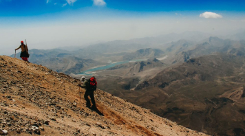
The height of Zardkooh is 4224 meters, and after Dana Peak, it is the second-highest mountain in the Zagros mountain range and one of the most prominent peaks in the world and a popular location on our Iran Trekking Tours.
Geographical Location of Zardkooh Bakhtiari
Zardkooh Bakhtiari (or Zardeh) mountain range is located between the two big rivers, Koohrang and Bazoft, in Chaharmahal and Bakhtiari province. The direction of this string from northwest to southeast is coordinated with the general movement of the Zagros structure.
This mountain range is one of the richest natural water reserves in Iran, and some of the primary sources of Karun River, as the largest river in Iran, and some of the main sources of Zayandeh Rood originate from this mountain range.
These heights are in the form of a strip with a width of about 15 km, including high peaks above 4000 meters such as Kino, Haftenan, Shahshahidan, Zardeh, Cheri, Klonchin, etc. Meanwhile, Klonchin Peak is the highest peak of Zardkooh Bakhtiari, with a height of 4224 meters.
Klonchin Peak reaches Shah Shahidan Peak, Dozerdeh Peak, and Haft Tanan Peak from the northeast side, and Cheri Peak and Mili Mountain from the southwest side. The wall is about 200 meters on the north side of Klonchin, and the peak can be accessed from the south side by a path. Exploring the diverse peaks and trails around Klonchin offers a glimpse into the beauty of north Iran tourism, where breathtaking landscapes and mountain adventures await.
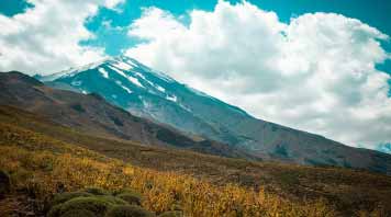
Also, the main glaciers of Zagros, which have an ice core, are located in the Zardkooh mountains, the most famous of which are the Ilok (Iran’s longest natural glacier), Porsonan, and Khorasan glaciers.
Zardkooh Shelters
The Chalmishan Shelter and Khorasan Shelter were built on the eastern slopes of this peak. Chalmishan shelter was built from metal, and the Khorasan shelter is built from stone with a metal roof. There is a water well next to Janpaneh Chalmishan.
Tange Khadang
A gorge with the local name of Tange Khadang and the popular name of Tange Klonchin is one of the climbing routes to Klonchin Peak. Tange Khadang is located at the top of the exit of the second water transfer tunnel from Karun tributaries to Zayandeh Rud.
This tunnel brings water from a place called Marboreh to the bottom of Kul Khadang, where after accumulating behind a dam, it directs it into the reservoir of a hydroelectric power plant, and after leaving the power plant, it goes to Zayandeh Road.
The Significant Peaks of Zardkooh Bakhtiari
Zardkooh has many peaks above 4000 meters, the most famous of which are Klonchin Peak 4221 meters, Chegale Peak 4136 meters, Haftanan Peak 4109 meters, Darvish Kezli Peak 4078 meters, Shah Shahidan Peak 4076 meters, Nazi Peak 4075 meters, Chaltau Peak 4075 meters, Tia Pea 4053 meters, Serang Peak 4011 meters, Dorang peak 4009 meters, Do-Zarde peak 4000 meters, Sirdan Peak 3988 meters, Qanbarkash Peak 3970 meters, Pele Long 3947 meters, Mishan Peak 3897 meters, Ilok Peak 3837 meters and Abesefid Peak 3759 meters.
Climbing Routes to Klonchin Peak
There are three common routes to climb Klonchin peak from Chalgerd city, Chaharmahal province, and Bakhtiari.
1. North ridge, the first dam of Koohrang tunnel and Janpanah Chalmishan, this path is associated with rocks and a lot of steepness, and to reach the peak, you have to travel a long distance.
2. Eastern valley, the second dam of the Koohrang tunnel, Khadang valley, which is often covered with snow and is the fastest way to reach the peak in the hot season, but due to the danger of avalanches, it is not possible to climb in the winter. Only at the beginning of the valley are there hazardous rocks.
3. Eastern ridge, the refuge of Khorasan, which is a suitable route for a winter ascent.
Winter climbing and the Best Time to Climb Zardkooh
Winter climbing to the peaks of the Zardkooh region (Klonchin, Shahshahidan, and Haftenan) is one of the difficult and long climbs.
Although the routes to the peaks of this region are not technical, due to a large amount of snow in the Chalgerd and Kohrang regions and the danger of avalanches, as well as the unstable and bad weather for several days in this region, winter programs require careful planning and practice. The best time to climb this area is in August and September.
View from the peak
If the weather is clear, the peaks of Shah-e Shahidan, Do-Zerdeh, Haftenan, Cheri, and Koh-e Milli of the Zardkooh range and Ashtrankoh peak in the northwest and Dena peak in the southeast can be seen from Klonchin peak.
Many rivers originate from the Zardkooh mountain range, such as Bazoft, Koohrang. In general, the eastern slopes of this mountain range lead to Kohrang and Ab Zak, its western slopes lead to Bazoft and the Lab River, and its northwestern slopes lead to Ab Elkan and Laweh Valley.
The annual rainfall of Zardkooh is between 800 and 1200 mm, and its average temperature is between 5 and 15 degrees, and it is considered one of the semi-hazardous areas in terms of seismicity.
The Koohrang dams are located on the eastern slopes of this range, and the water stored in them is transferred to the Zayandeh Rood catchment area through the Kohrang tunnel. Ilok, Porsonan, Khorasan, Khadang, and Qanbarkash are among the important permanent glaciers of the Zardkooh region, which are the main source of the Bazoft and Koohrang rivers.
Features of Zardkooh Bakhtiari Region
Among the important features of the Zardkooh region we can mention Il Bey and Porsonan glaciers, the valleys of Khadang and Khorasan, the Nazi lake, and the single-tree forests of Bazfat.
(Kol = narrow, very narrow valley and Khadang = arrow, spear) Zardkooh glaciers and ridges are very beautiful, spectacular, and at the same time dangerous. Zardkooh has very cold nights and scorching sunny days.
The Zagros mountain range is located in the west and south of Iran, which started from the shores of Lake Van in Turkish Kurdistan and after passing through the provinces of Azarbaijan, Kurdistan, Kermanshah, Isfahan, Chaharmahal Bakhtiari, Khuzestan, and Lorestan, it continues to Fars and Kerman provinces.
Zardkooh Bakhtiari is located in the Middle Zagros. Lake Gohar is also found in the Zagros mountain range, and Zagros is one of the rarest areas for the growth of all kinds of unique medicinal plants in the world. In addition, inverted Koohrang tulips are rare in the world.
Rivers of Zardkooh Mountain Range
Zardkooh is the starting point of two extremely historically significant rivers in Iran. The Zardkooh Bakhtiari mountain range is in southwest Iran and extends from the westernmost part of Chaharmahal and Bakhtiari province to the east and northeast of Khuzestan. This mountain range is one of the richest natural water reserves in Iran, and the country’s two rivers with abundant water (Karun and Zayandehroud) originate from its slopes.
Karun River
Karun River is the largest and most abundant river in Iran. With a length of 950 km, this river is the longest river that is located only inside Iran, and it is also the only river in Iran whose part is navigable. The drinking water of the Ahvaz metropolis is supplied by the Karun River.
In History, the plain of Susa, where pre-historic civilizations from the fifth millennium BC were found, such as the recently discovered ancient culture from the Zohreh, were fed by the Karun River. The Elamite civilization, which flourished around the early third millennium to the Persians of 500 BC, later settled in the Karun valley as well. Several times throughout history, Mesopotamian-based kingdoms like Ur and Babylon defeated the Elamites and took control of the Karun region and its surroundings in what is now known as Khuzestan. Susa was one the largest cities in Mesopotamia and one of the two great cities of the Elamites before the Assyrians destroyed it.
The Karun River is assumed to be the Gihon River of biblical fame. Where it is mentioned as the second river in the book of Genesis. This theory was put forth by the archaeologist Juris Zarins who locates the Garden of Eden at the northern tip of the Persian Gulf (now undersea), fed by the four rivers Euphrates, Tigris, Gihon (Karun), and the now-extinct Pishon.
Zayandeh Rood River
Zayandehrud is the most important river in central Iran, which originates from the 3-4,000-meter-high Chekad of Zardkooh Bakhtiari and Kohrang in Chaharmahal Bakhtiari province.
For millennia, people have inhabited the Zayandeh River’s banks. In a cave site called the ‘“’Qaleh Bozi’, southwest of Isfahan, archaeologists have discovered the earliest signs of human habitation along the River. The ‘Qaleh Bozi’ caves were inhabited by Neanderthals hunting groups of the Palaeolithic, more than forty thousand years ago, leaving behind stone tools and the remains of the animals they had hunted. However, Zayandeh Rood is considerably more famous as Isfahan’s life-giving riverbed of the Capital of the Safavid Empire. The river with its many canals and bridges ran through the many economic, cultural, and administrative centers and hubs. And provided water for Isfahan’s agriculture and growing population.
This river enters this province from the west side of Isfahan province after going through a winding path in Shahrekord city. The name of the Zayandehroud river has always been linked with the name of the city of Isfahan, in such a way that wherever the name of Isfahan is mentioned, everyone knows this beautiful city with its famous river. If you want to visit the area and see all it has to offer visit our Iran Tailor-Made Tours and explore the are on your own terms.
The Bakhtiari Tribe
The Bakhtiari people are made up of two major clans: Haft-Lang and Chahar-Lang. The residents of Chal Gerd are from the Babadi clan, and the residents of Birgan and Ab Barik are from the Behdarvand clan. Both of these clans are Haft-Lang. The Bakhtiari population of the country is estimated to be around 3 million people.
1. The Bakhtiari people have been one of the most powerful and influential people in Iran’s governmental destiny in recent years and are known as the defenders of Iran’s freedom.
2. According to some of the land of Bakhtiari, great descendants include legendary and historical figures such as – Kaveh Ahangar (Kaveh the Blacksmith) – Cyrus the Great – Ariobarzanes – Mana – Kian – Kay Kawad – Kay Khosrow – Khorzad (Lady of Anzan) – Siavoshan – Arin – Sardar Asad Bakhtiari, the conqueror of Tehran during the constitutional revolution – the leaders of the Kandahar and Indian cavalry during the conquest Nadershah Afshar. Other contemporary figures from this land are Mohsen Rezaei – Qeysar Aminpour – Hossein Pejman Bakhtiari- Darab Afsar Bakhtiari – Sardar Maryam Bakhtiari.
3. Some have claimed that until the Pahlavi period, when the government of Iran was a monarchy, the border of Bakhtiari land, which includes a part of Isfahan province – Chaharmahal and Bakhtiari province – Khuzestan province and a part of Lorestan province, was more than three thousand years and was never moved.
At the time of Alexander’s attack on Iran, when the whole of Iran fell due to the betrayal of some Iranians, Alexander’s army could never dominate the central part of Bakhtiari.
Even during the invasion of Iran by the Arabs at the beginning of Islam and the complete fall of Iran, the Arabs could not dominate the central part of Bakhtiari, and the Bakhtiari’s accepted Islam about 376 years after Islam because the Islamic government was based on the administrative system of the Sassanids and then became Shia.
4. It is said that the Pattern of Chogha, which is a men’s top, is taken from the Chaghazanbil building, which is the first ancient monument of Iran registered by UNESCO.
The inversion of this pattern was formed after Alexander’s attack on Persepolis and the commemoration of the martyrs of the Protection Guard of Persepolis under the command of Ariobarzen. In addition, the pattern that is formed on women’s skirts with goes back to ancient Iranian holy places.
5. Bakhtiari tribe and Qashqai tribe are the only Iranian tribes that are still nomadic.
6. Iran’s first oil well was drilled in Bakhtiari land with the participation of Bakhtiari Oil Company and England.
7. 45 to 50% of Iran’s ground and underground water reserves are from the Zagros mountains, where the Bakhtiari people also live.
8. Zayandehroud, Karun, Karkheh, and Dez rivers originate from the Zagros mountain range. Some of the most important dams and power plants are in Bakhtiari land.